How digital mapping tools and location apps have transformed everyday navigation.
Your smartphone is your camera. If you’re out and about, and are taking photographs of your adventure, you’re probably (nah, let’s be real – definitely) using one of your phone’s built-in cameras.
But stop and look around. How did you get where you were going? If it’s a place you haven’t been before, you probably – no, definitely – used a navigation app. That’s because your smartphone is also your map.
How We Got Here
It’s been like this for a couple of decades already. Google Maps (iOS, Android) launched on mobile in 2006. Apple Maps followed in 2012, becoming the iPhone default for iOS6. Those early versions did what paper maps did, but better: they showed you where you were on the map, and gave you turn-by-turn directions to get where you wanted to go.
It was a total game changer. (Ask your parents.) Instead of using paper maps and map books, and trying to triangulate your location using street signs, landmarks and the wings of angels, you could now just follow the dot on your smartphone screen.
But then maps – and apps – got smarter. Mobile navigation tools like Waze started letting users report traffic jams, road accidents, speed traps, and detours. Now, instead of watching as your little dot sat in a bumper-to-bumper commute, your app would tell you where the delays were, how long they were and which sneaky side roads to take to avoid them entirely. It was beautiful. (Again, ask your parents.)
Where We Are
Today’s mapping apps are more sophisticated than ever. Google Maps, Apple Maps and Waze provide route planning and traffic data. But they’re just the tip of the route-finding, real-time-data iceberg.
Garmin Connect and Strava track your route when you’re running or cycling, providing fitness data while letting you a) brag about your run/cycle while b) not getting lost. AllTrails, meanwhile, is a good option for hikers and trail runners.
Meanwhile, Life360 is meant as a fleet-monitoring app, but most of us use it to keep track of our kids and family. (Tell your parents.)
And, if you want to arrange a meeting spot with friends in a crowded or confusing place, what3words has mapped the entire surface of the Earth using unique three-word combinations. Meeting mates at the V&A Waterfront’s Nobel Square in Cape Town? That’ll be ///worker.treasures.yeasts. Meeting friends for the derby at Soccer City? See you at ///gladiators.squeaks.fuss.
That’s where we are, and how we got here (metaphorically speaking). Where will digital mapping technology take us next?
Where We’re Going
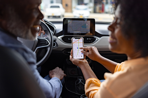
Google recently introduced significant updates to Google Maps, bringing in an AI-powered conversational assistant and 3D Immersive Navigation that make directions clearer and more intuitive. The AI element takes navigation to a whole new level, letting you ask the app complex questions in natural, everyday language.
Things like… “Where can I get vegan food along my route?”, “What are some unique things to do with my kids in Durban this weekend?”, or “Is there a gym nearby that offers yoga classes?” Instead of just showing how to get to where you want to go, your digital navigation tool will now help you find new places to explore.
That’s the future of map apps… and we’ve already arrived.
Browse our latest stories to experience tech made easy.